Marking Time: Postal Slogans in the Ken White Postcard Collection

In January 2026, the Museum team delivered a talk for the Lewisham Local History Society presenting initial findings from the cataloguing of the Ken White Postcard Collection as part of the ‘Wish You Were Here’ project. This included showcasing some stories that the team had found, demonstrating examples of the fascinating narratives that will emerge as the project continues. 

I joined the team attempting to grapple with the Ken White Postcard Collection (KWPC) in the summer of 2025, once all the individual postcards had been bagged and numbered and the systems of classification were well established. This is to say, I selected my box of postcards (Box 6) without any preconception of their contents or what historical period may be illuminated within. Box 6 ranged from the 1940s up to the late 1960s, so where other researchers found stories from the trenches, correspondences to and from the great houses built in South London after the raising of the Crystal Palace, and one postcard alluding to the rise of Nazism in Germany, I found the great majority of the postcards I categorised to boast bright coloured piers and flower gardens along seaside promenades, flagging the repeat key words of ‘holiday correspondence’ and ‘discussion of weather’. Postcards being used for holiday correspondence is not a post-War phenomenon, but the percentage of postcards about having arrived in Deal, or Bournemouth, or Torquay shot up.

Over the months of cataloguing this did considerably limit specific interest in the content of the cards. Alongside flagging keywords about the content and picture on the front, we logged where the postcards were sent to and from, who they were sent to and by whom, and if they had any remarkable stamps or postmarks. This final data set is where my research veered away from the team, a greater number of the postcards I was cataloguing had slogan postmarks as the stamp obliterator, alongside the constant town mark detailing the day the postcard was sent and where from. The repetitive nature of the content thus opened itself to tracking the history of the postcard and postmark as a tool for mass communication, detailing the commercialisation and professionalisation of the postal system in the 20th century.

The postmark is the ink stamp on the right side of a postcard, by the stamp. The first postmark was introduced by the English Postmaster General Henry Bishop in 1661. It showed the day and month a letter had been sent to prevent late deliveries by private postal companies. Whilst in the late 19th and early 20th centuries the postmark would be used to obliterate stamps, these marks preceded the stamp by nearly 200 years. The private delivery companies of the 17th century realised the commercial value of the mandated mark and used it to expand their potential markets by boasting fast delivery times
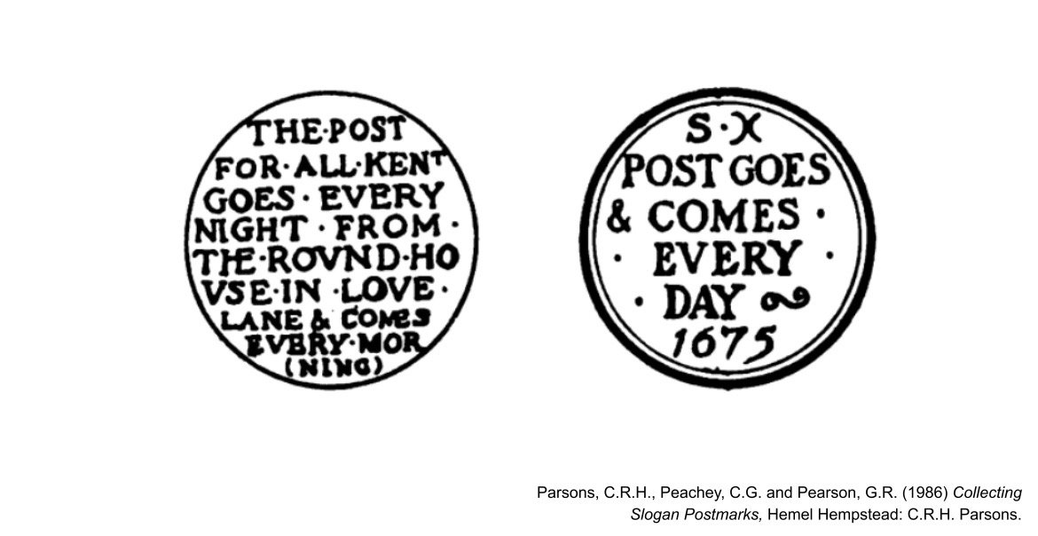
The first stamp was rolled out on May 7th 1840, and the stamp obliterating postal mark followed across the Empire by the 1850s. Despite the pioneering postal system in Britain, the adoption of text based postmarks, able to print slogans came about comparatively late, even compared to other countries in the Empire. In part, this was due to a desire not to cause unnecessary agitation in colonised countries, for fear that such a large amount of post was leaving the metropole for the then-colonies, any Britain specific slogans may upset the carefully curated sense of unity.

Campaigners had urged the Postal office to adopt advertisable stamp cancelling machines as early as 1871, with Pears, the soap company, suggesting an obliterating postmark bearing the word “PEARS”. The attempt was thwarted. The Government itself became the first allowed to exploit the stamp obliterating postmark for public advertising, with 1917’s plea “BUY WAR BONDS”.
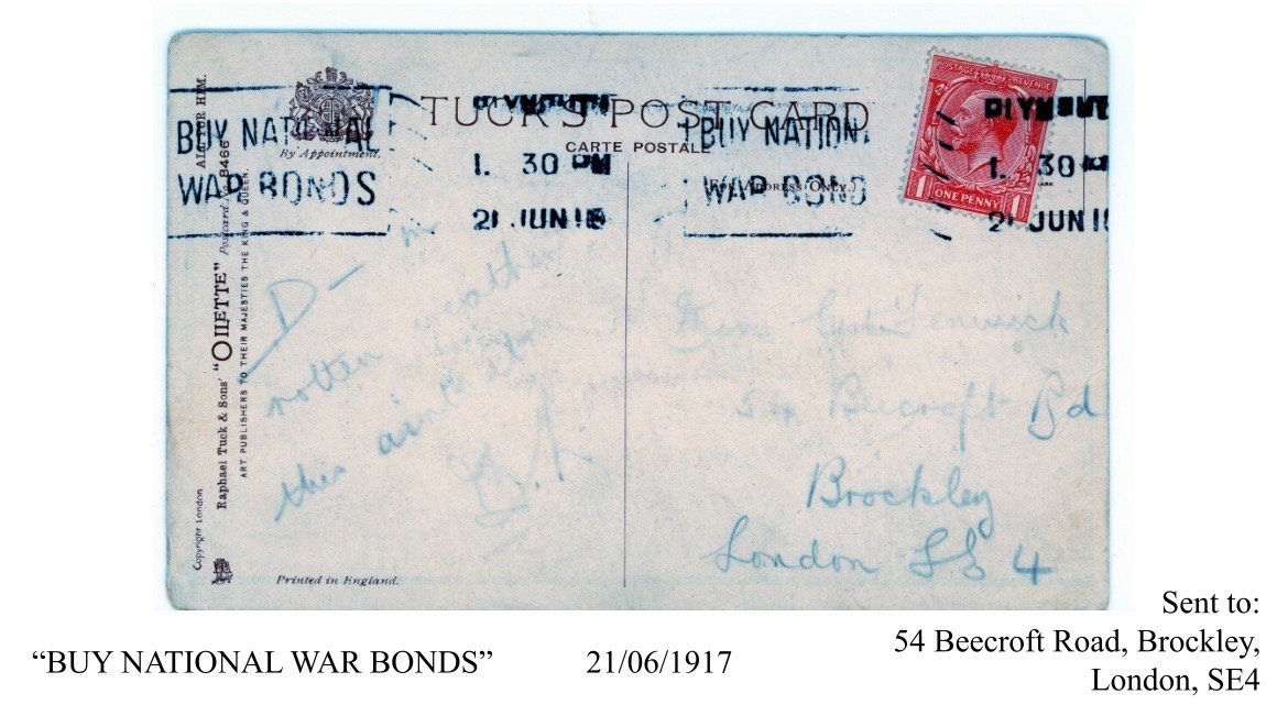
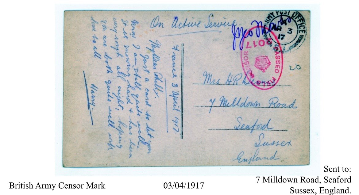
The earliest in the KWPC is from 1917 and was sent to Beecroft Road in Brockley. This was not the first time words were used to obliterate stamps in Britain, but previous public usage had been limited to military usage, such as the censor marks we found in the KWPC.
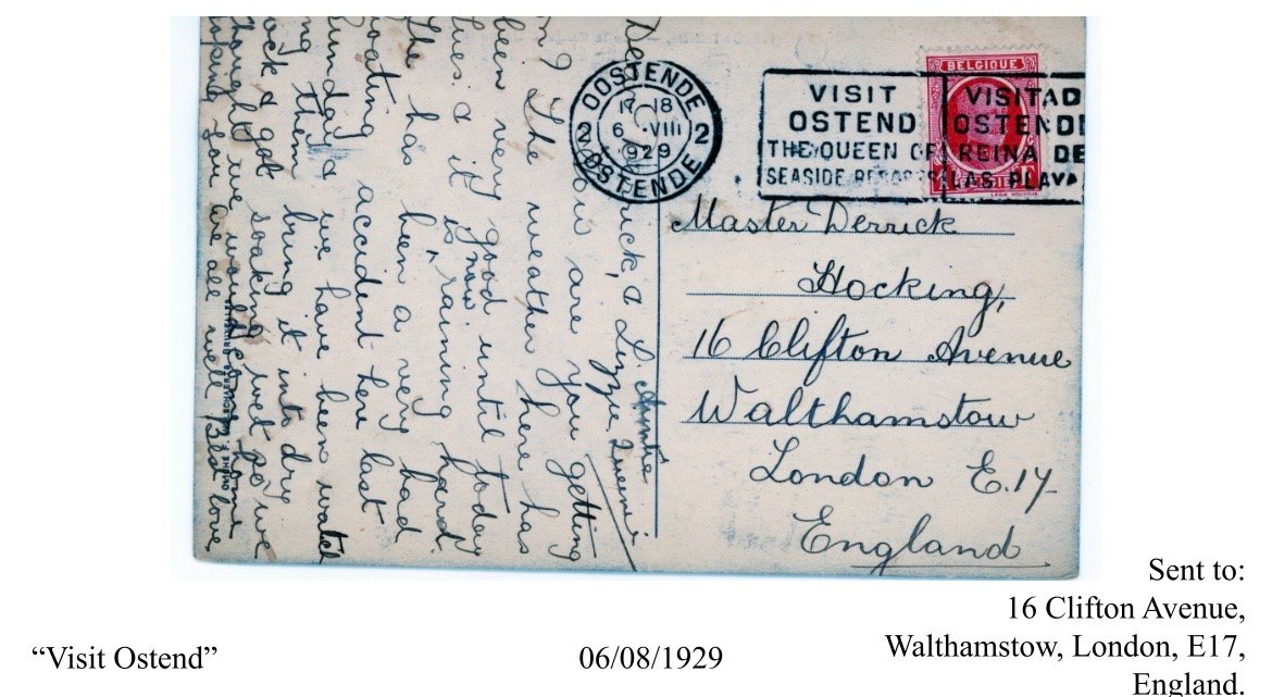
Meanwhile outside of Britain, postal slogans were already being used for local promotion such as this postcard we catalogued encouraging people to visit Ostend! The UK wouldn’t release an equivalent postmark until 1956 for the Rochdale centenary, unfortunately none if these have about in the collection at this stage.
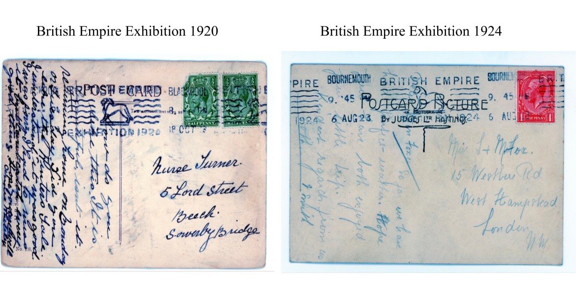
After ‘BUY WAR BONDS”, the first postal slogans stamped in peace time were used to advertise countrywide government adjacent events. Many postcards from the 1920s bore the mark “BRITISH INDUSTRIES FAIR” and “THE BRITISH EMPIRE EXHIBITION”.
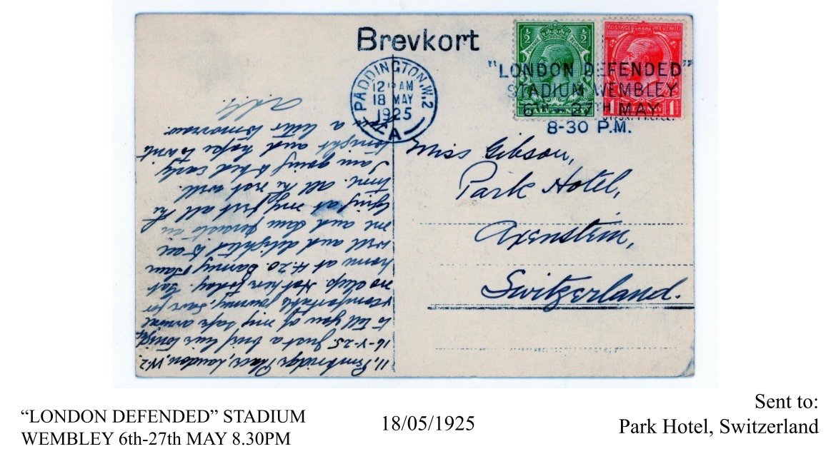
Some postcards we came across from 1925 read “LONDON DEFENDED WEMBLEY STADIUM” advertising an airshow at Wembley Stadium, itself only two years of age, between May 9th and- June 1st which saw the NO. 32 RAF squadron flying overhead, firing blank ammunition into the crowd, dropping pyrotechnics to simulate shrapnel and engineering explosions to imitate the effect of German bombs crashing onto a pitch which just a fortnight prior had seen Sheffield United beat Cardiff City 1-0 in the FA Cup final.
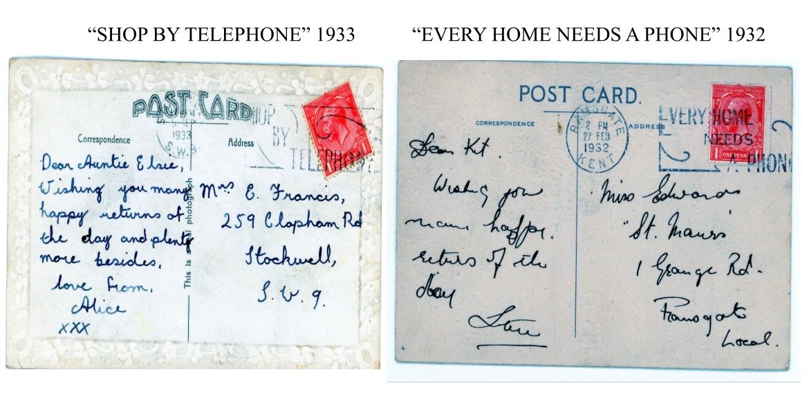
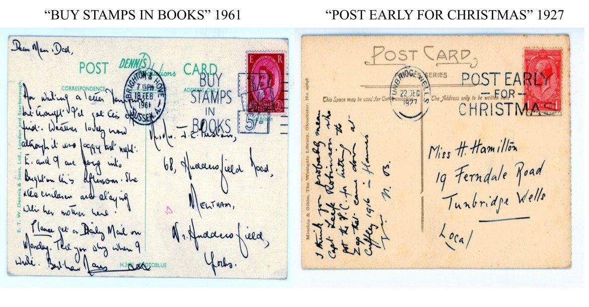
As the 1920s and 30s drew on, the slogan post mark was exploited for the promotion of new technologies e.g. “SHOP BY TELEPHONE” and “EVERY HOME NEEDS A PHONE” or for the Postal Office’s own public service announcements e.g. ‘POST EARLY FOR CHRISTMAS” and “BUY STAMPS IN BOOKS”.
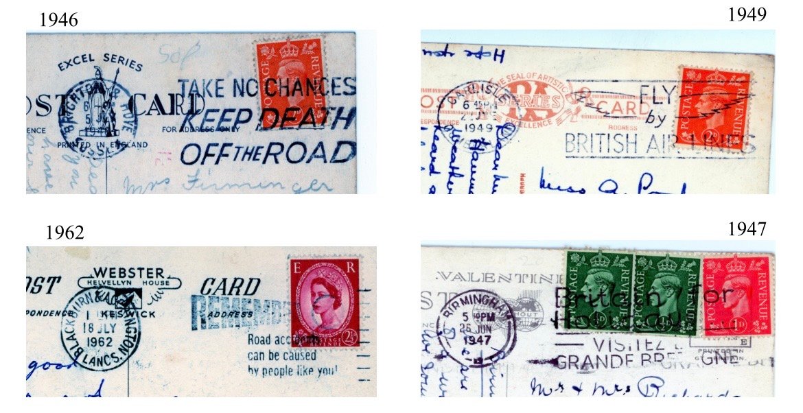
In 1926 provisions had been made to begin private advertising on the postmark, but this was scrapped following public backlash and an editorial from the Mail claiming the the plans would be illegal under the Postal Office Acts, though the Office itself would put the scrapping down to insufficient potential to generate funds. Following the Second World War attempts at mass government marketing expanded e.g. “FLY BRITISH AIRWAYS” and “TAKE NO CHANCES KEEP DEATH OFF THE ROAD”, as did general public informational messaging encouraging giving blood, and even postmarks aimed outside of the British Isles e.g. “Visitez le Grande-Bretagne”. Still, the slogan postmarks continue throughout the KWPC to reveal a modernising Britain, but still under the strong grip of the central government using post as a subtle form of mass communication.
 

Screenshot

Some slogans would appear more commonly in the collection than others, a microcosm of the effect of the roll out of these campaigns. Slogan Ostmarks were generally specific to certain post offices, even if they were intended for national distribution. The sponsor of a postmark would arrange for their distribution in such a way as to ensure the largest coverage for the least money as possible. A national slogan like “FLY BRITISH AIRWAS”which commonly cropped up in the KWPC, running from the Second World War til 1963 would be the result of the production of 350 dies (which would stamp the obliterating mark) to 250 sorting offices, generally targeting large towns.
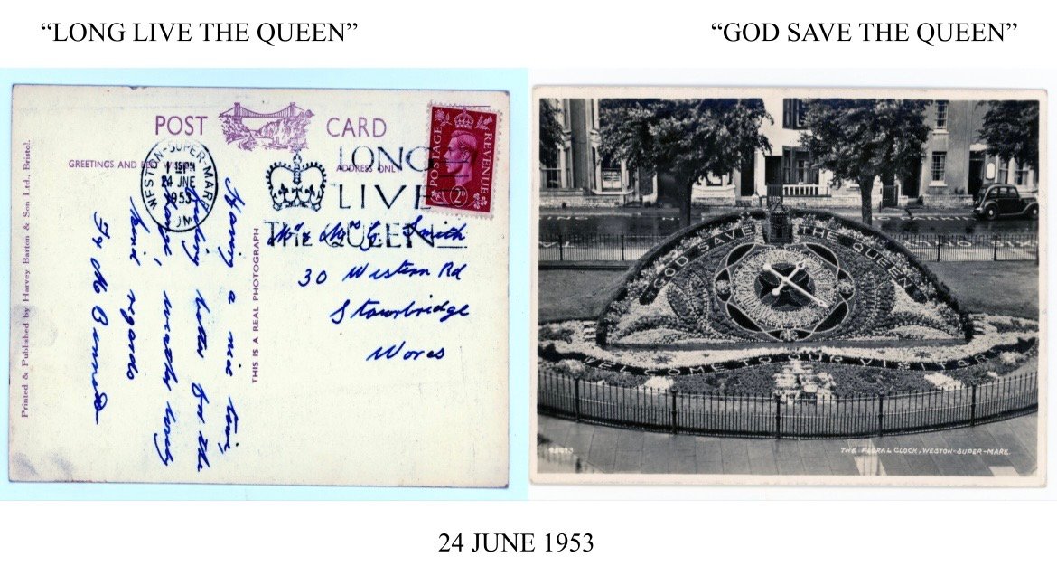
The notable exception to this trend for nationally rolled out postmarks were issued for the Victory, the Royal Wedding of Elizabeth and Phillip and the Coronation, for which 921 dies were issued. The postmark once again acting as the subtle hand of state messaging, at a rate where other such tools lagged. One such example, a personal favourite of mine in the collection, bearing a “LONG LIVE THE QUEEN” postmark matching a flowerbed arranged for the Coronation, but sent with the stamp of the deceased King George VI.

In South East London the participating sorting offices for slogan postmarks were London SE1 Delivery office in Bermondsey, Camberwell SE5, Catford SE6, Eltham SE9, Lewisham SE13, Peckham SE15, and Woolwich SE18. Catford and Lewisham were deleted from the National list during revisions in 1960. As for local slogans, they wouldn’t appear until 1956, and only then to celebrate civic anniversaries or local events. It was not until the 1st of April 1963 that postal slogans promoting tourism or investment, like that sent from Ostend, were permitted in Britain, just in time for the average Briton to surface from the financial struggle of the War and consider a seaside holiday.

Some of my favourite postmarks in the collection appear from 1965 onwards, when ladening rules allowed for pictures on the postmarks. The success of these postmarks and the renewed hope of advertisers to exploit the space led to a substantial change in the marking of postcards by post offices. When we came to analyse each postcard from the KWPC, one of the most useful tools was the town mark, the small circular stamp which allowed us to identify when and where a postcard was sent from. This was to the left of the stamp, with the postmark and its obliterating lines or slogan over the stamp to the right. Useful to researchers, yes, but inopportune for paying sponsors whose designs became obscured by the stamps underneath, or cut off by the edge of a postcard. From July 1st 1963, however, this would change. The circular impression was allowed to be used as a stamp obliterator on the right, with the postmark on the left.
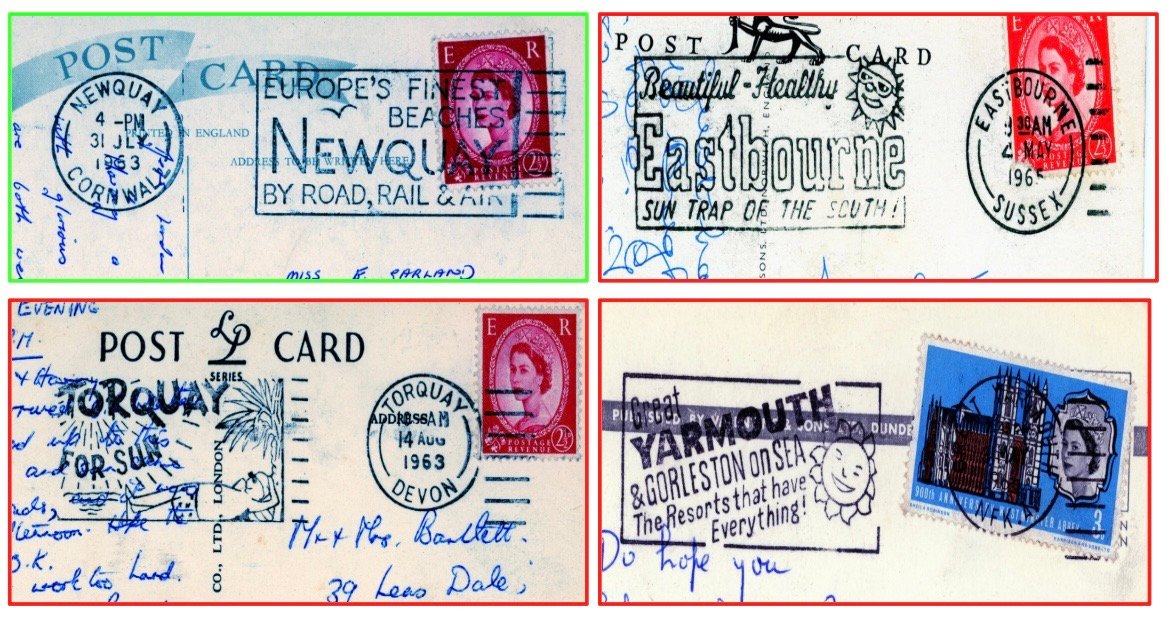
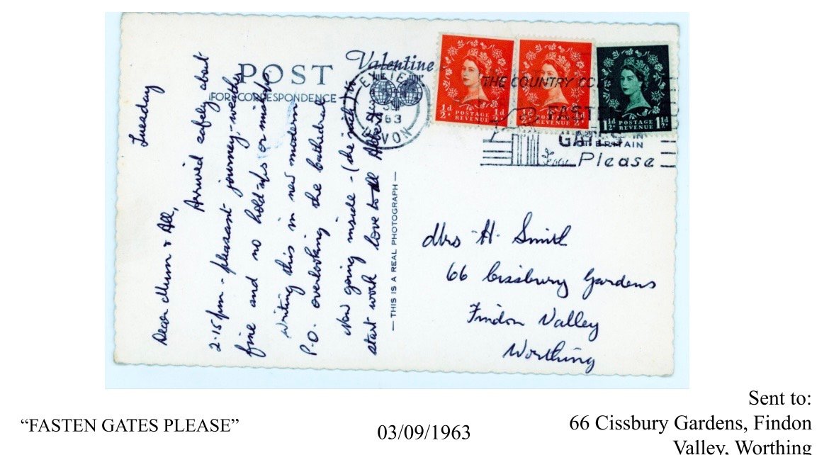
By 1968 this order was commonplace and would be standardised by 1976. And thus, the desire expressed by Pears in 1871 was fulfilled 100 years later, the postal slogan and its potential for mass marketing was ultimately realised, usurping the practical postal function of the mark and town stamp. However, The KWPC illuminates that the development of the postmark was still largely taken advantage of by local action groups or the Post Office itself. One postmark that appeared in the collection urging the fastening of gates was the result of a campaign of only 10 dies used in 12 offices (two were transferred) distributed in Devon.
Among the most important in this collection are from Norwich which mark not just the use of local slogans in the 1950s, but the standardised introduction of the postcode, first trialled in Norwich in 1959, before being rolled out to Croydon and beyond from 1966. Whenever a town got a proper, 6-digit postcode, a postal slogan was issued “REMEMBER TO USE THE POST CODE”, running for 6 weeks or longer.
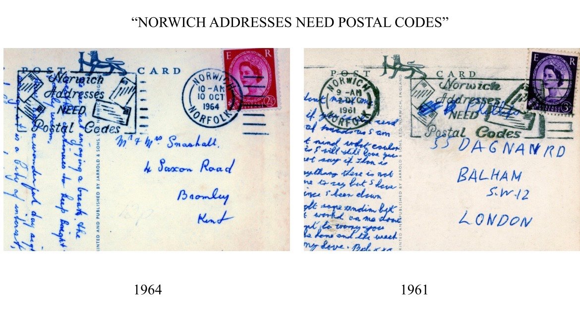
My research of the KWPC never went enough post the 1960s to be able to confidently analyse the development of slogan postmark technology beyond this time, which would have likely been affected by postal strikes in 1971, and the introduction of the first class stamp. But, using the data drawn from KWPC we are able to map out a history of the Postal Service as a tool for fast mass communication, seeing Britain evolve from a centralised nation with war at the heart of its concerns, to a consumerist, holidaying economy with a formalised civilian postal system.

Though the stories we can draw out from the collection may be more obviously interesting, the postcards bare witness to much more than the lives of the people who wrote them, if what we can pick up from the postmark obliterating the stamp can be so revelatory for the change of British society over the course of the 20th century, what can the stamps tell us, the producers of the postcards, the change in addresses and post offices and holiday destinations tell us about our history. As such I am glad to have been drawn into this history through an often resented repetitive logging of “discussion of weather” and “holiday correspondence”, though sometimes I may have wished for a bit of gossip along the way.

Kate Fothergill, Archive and Research Assistant
Seeking Conduit Street: the realities of an ever-changing London landscape

In January 2026, the Museum team delivered a talk for the Lewisham Local History Society presenting initial findings from the cataloguing of the Ken White Postcard Collection as part of the ‘Wish You Were Here’ project. This included showcasing some stories that the team had found, demonstrating examples of the fascinating narratives that will emerge as the project continues. 

One thing that ceases to be torn from its novelty when cataloguing the Ken White Postcard Collection is coming across locations that I recognise from ambling around the sprawls of streets in the the places I call my home. It is not necessarily extraordinary, given the flurry of postcards darting across London in the early twentieth century – its apogee was shortly before, with 1889’s twelve deliveries a day. It remains exciting though, bringing to the fore the reality of these everyday stories that that archival social history reveals, managing to close the distance between past and present.

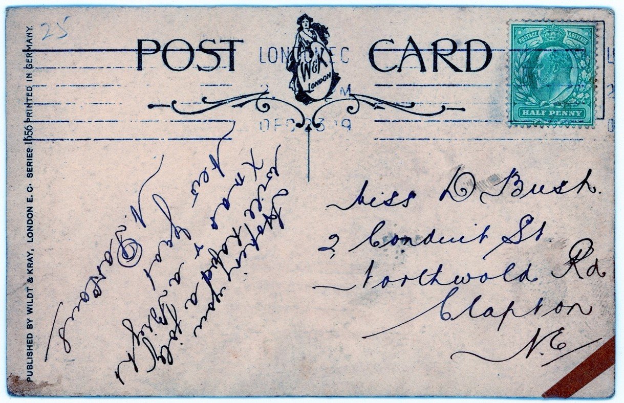
A postcard that caught my attention for such a reason was addressed to Miss D. Bush, from N. Parsons, postmarked as 23 December 1919. It was sent to ‘2 Conduit Street, Northwold Road, Clapton’. It was not the address, per se, but the fact that it didn’t exist. I have traipsed up and down Northwold Road countless times and was certain that a Conduit Street does not exist there. In trying to place the location of its initial delivery, postcard 0504 revealed a pattern of change and movement across London, emanating from individual actors, such as Daisy, state-led incentives, and commercial interests.

Written Postcard

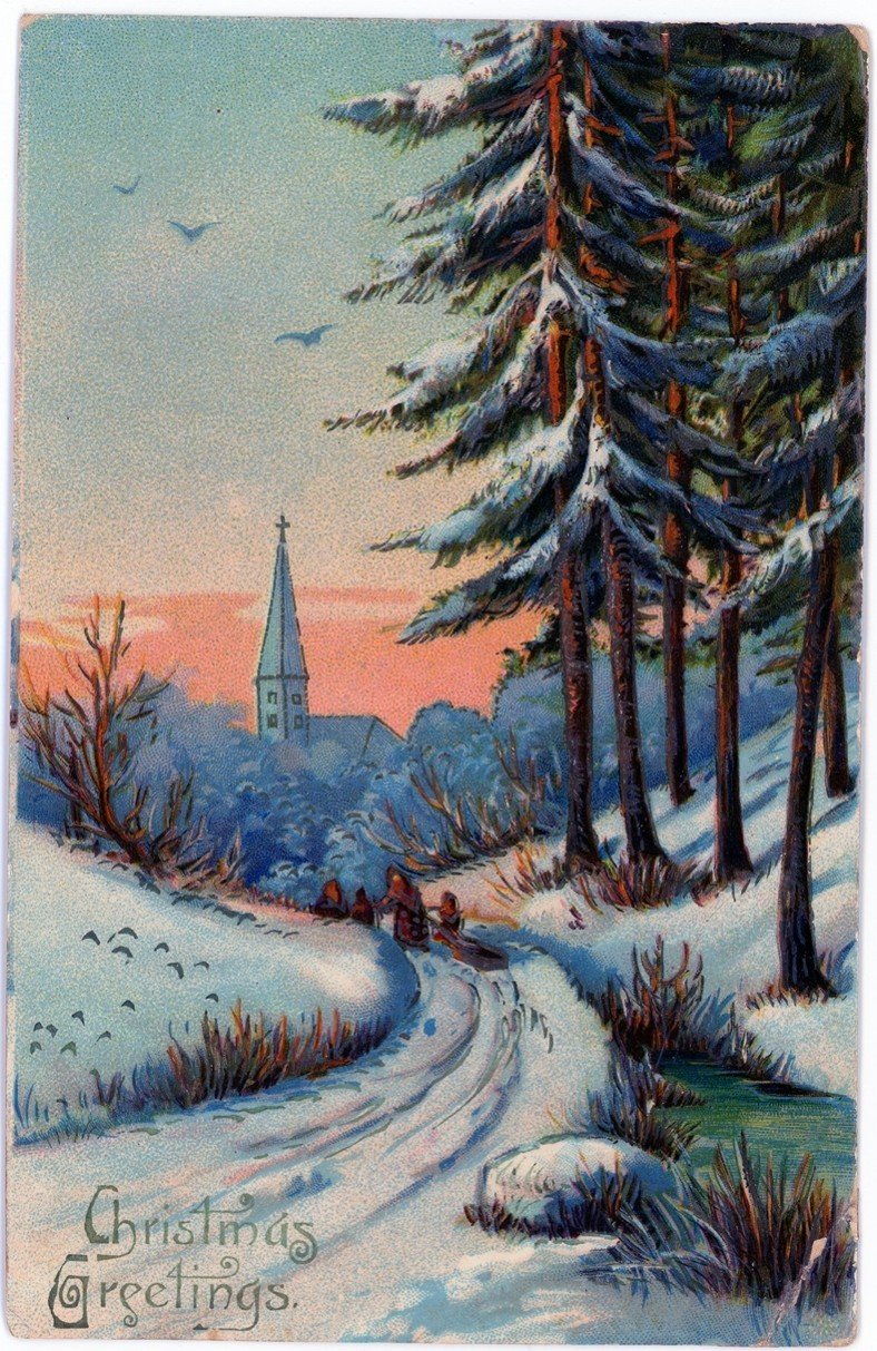
It was a Christmas card, its brevity in keeping with many of the cards we come across. The design is beautiful, an illustrated snowy scene with a church, with a swirled font, too, is typical of many from that period.

Finding Conduit Street.

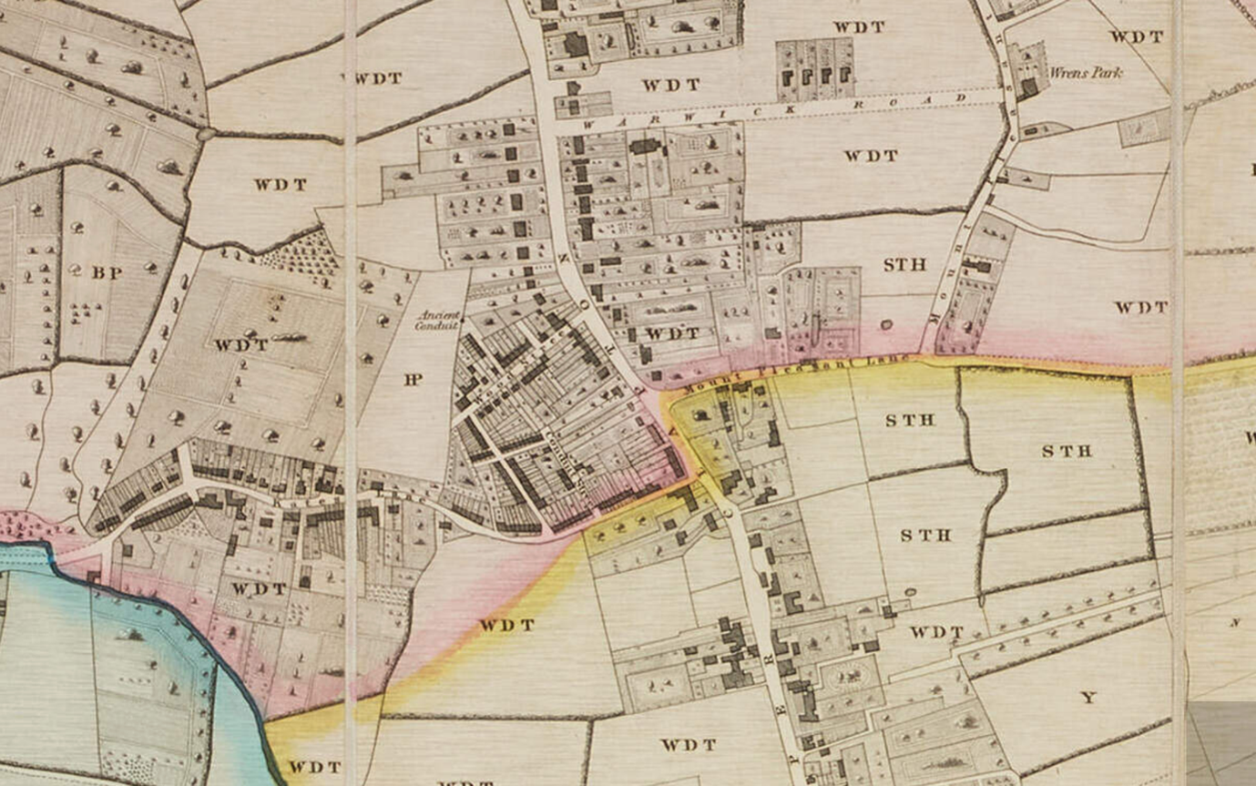
A map published in 1831 covering the parish of St John at Hackney reveals a Conduit Street jutting off from Kate’s Lane, now known as Northwold Road. The imprint of Conduit Street lines up with today’s Rossendale Street, and Wood Street, to the north, is now known as Rossington Street.

Plan of the Parish of St John at Hackney, 1831
H. Ashpitel and Thomas Starling, Plan of the Parish of St John at Hackney (1831).

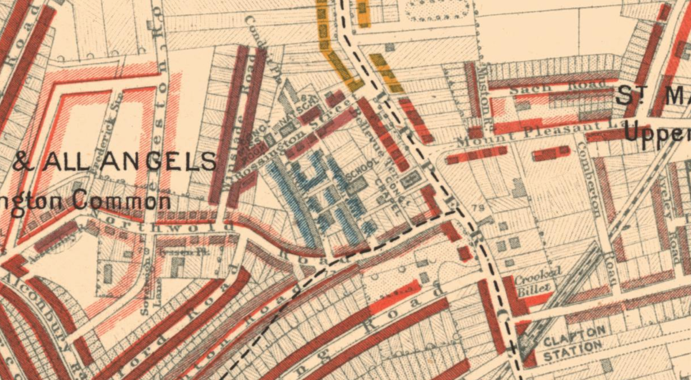
Conduit Street is also seen in sheet two of  Charles Booth’s poverty map of 1889-99. This was the second edition, following the first based on surveys conducted ten years prior and covering a smaller area, The poverty maps, using Stanford’s Library Map of London and Suburbs as a base, use colour-coding to elucidate the variance of living conditions for households and communities across London. Data was compiled through empirical research, with Booth and others conducting the survey engaging in street-level inquiries. Emergent was a stark depiction of wealth and class disparity, and gave a harrowing impression of the true level of poverty found in the city.

Charles Booth, Descriptive Map of London Poverty (1898-9), Sheet 2

The area of Conduit Street appears as a light-blue enclave, surrounded by red. In his notes of this trip to the area around Conduit Street, Booth suggested that the street should be a mix of light-blue and purple. Light-blue indicated generally a poor standard of living and wages. Purple was a mixture of poor and more comfortable, and the surrounding areas of Conduit Street were middle-class to well-to-do.

Tracing D. Bush.

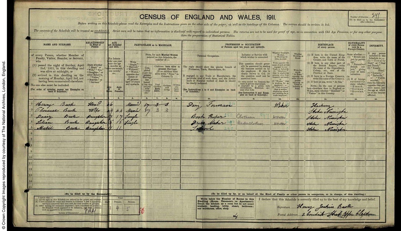
In the 1911 Census of England and Wales, living at 2 Conduit Street were Henry and Florence Bush, with their three daughters Mabel, Lilian, and Daisy Bush, the eldest. This is the Miss D. Bush to which the letter was addressed.

Census Return for 2 Conduit Street, Upper Clapton (General Register Office, RG 14/11225 Sch 277)
 “Daisy Bush,” 1911, Census Return for 2 Conduit Street, Upper Clapton (General Register Office, RG 14/11225 Sch 277), www.findmypast.co.uk.

Daisy’s profession was a book keeper in the textile industry, with the census listing her as seventeen years old. Her appearance in the 1939 Register confirms she was born in 1893, in June. This would make her twenty-six years old at the time she received the postcard from N. Parsons in 1919. Daisy’s sister, Mable, aged fifteen, also worked within the textile industry as a dressmaker; this industry was a common source of employment for women and girls at the time, with this beginning to weave a tapestry of a working-class family in early twentieth-century London.

The 1921 census for the household, conducted two years after the postcard was dated, lists the postal address as 138 Northwold Road. 138 Northwold Road does not exist anymore, but based on the contemporary street numbers, it would be placed yards from the entrance to Conduit Street. Given that Lilian Bush does not appear on this census, the family may have downsized to somewhere close by. Listed as living at 2 Conduit Road in the 1921 Census is the five-person Lines household.

In 1921, Daisy Bush was working as a clerk for Ellis Buckle Ltd, with employer’s address listed as 9 Walbrook, in the City, about a stone’s throw away from Bank station. There was little to be found about the company itself, though clerical work, like the textile workers of the earlier decades, was a prominent avenue for which women to enter the public-sphere of the workforce, especially in the aftermath of the Great War and expanding businesses; though, women working as clerks were by no means a new development.

In the 1939 register, an emergency precaution on the outbreak of war, Daisy and her widowed mother are recorded as living in a household with Mabel, now married to a Thomas Leeper. Both Mabel and their mother are listed as working in positions of unpaid domestic labour, whilst Daisy, single, was still in employment as a register secretary. Also recorded as part of the household was a married man named Robert Williams who worked as a stock jobber and auxiliary fire fighter. They had moved further from Conduit Street by this point, now residing in Edmonton. It takes about an hour and two buses to make the journey between the two addresses today.

The move northwards to Edmonton gestures to a broader trend of suburbanisation in the interwar years. By the tail-end of the 1930s, the population of London’s suburbs had boomed by 2.5 million, the geographic radius of what we call London similarly expanding. Facilitating this was the expansion of the public transport network across London. This was particularly noted in North-West London, developments of the Metropolitan Railway heralding ‘Metro-Land,’ so dubbed in promotional materials produced by the Metropolitan Railway, which would in 1933 become incorporated into the precursor of the London Underground we know today. Whilst it had its specificities, Metro-Land was not the sole stop for suburbanisation, Edmonton itself being served by Silver Street station, operational since 1872 and now a stop on the Weaver Line of the London Overground. New rail links and, indeed, recognition of the importance of these earlier local networks, contributed to the changing landscape of London, both infrastructurally and demographically. Daisy Bush’s relocation to Edmonton is one person’s story in the broader movement.

Building as Rossendale Street.

By the time the Bush family had established themselves in Edmonton, Clapton’s conduit street no longer appears in the records. Many streets were renamed around London, largely due to duplication. A concerted effort to rename streets went into full thrust in the 1930s, converging with another facet of the radical restructuring of London’s residential geography.

The 1930 Housing Act heralded a wave of slum clearance across the country, building on pressure already mounting on local councils stemming from the 1919 Housing Act.

The Act compelled private landlords to sell slum housing to local councils, the slum housing was then cleared and new housing erected on the site. These new homes were often blocks of flats devised as five-storey walk-ups for efficient usage of ground space. By 1939, around 240,00 slum houses had been cleared, with some 700,00 new homes built. Accompanying this municipal undertaking was a deluge of promotional materials produced by both London County Council and various borough councils, such as this short-film produced by Hackney Council.

Also, the film ‘Housing Problems’, released in 1935, documents the media diffusion of contemporary overcrowding and slum-housing. It also projects a certain optimism courted by this council-funded social work. These L.C.C. homes weren’t the first council blocks built by the council, but they remain an enduring symbol of this interwar flurry of building. The new blocks featured prominently in L.C.C. publications, often highlighting their aesthetic and civic value. The blocks remain dotted around, a distinctive part of London’s residential landscape and a material testament to history of housing in the city, which remains in flux to this day.

Numbers 12 to 18 of Conduit Street were identified as clearance areas alongside various other streets in the vicinity in a series of documents from 1931, found in Hackney Archives (H/PD/3/6/1). Also within the Archives are records of the actual clearance order, this time for the entirety of Conduit Street, from 1934 (H/PD/3/3/12). It is reasonable to assume that following completion of the clearance order, Conduit Street was renamed and the site of council building, with a block remaining on the corner today, called Rossendale House. Incidentally, where 138 Northwold Road, the 1921 residence of the Bush family, may have been, is also the site of 1930s-era council housing.

Conclusions

The story of Daisy Bush and the address in which she resided when receiving postcard 0504 reveals the realities of an ever-changing London landscape. It provides a tangible reminder that the streets of London, whilst old, not unchanging, shifting cannily through intersections of industrialisation, social welfare, suburbanisation, and transport. Unravelling these intersections enliven built environments their interaction with social history. Whilst I have recounted the story of a specific street, and a specific postcard recipient, it was a narrative playing out across London, and indeed the country as a whole.

Madeleine Beaumont-Grice, Archive and Research Assistant

Box B2a

Please click on an image to view the relevant archival information and further images of each item.

B2a_008068
B2a_008069
B2a_008074
B2a_008078
B2a_008079
B2a_008080
B2a_008081
B2a_008082
B2a_008083
B2a_008086
B2a_008087
B2a_008089
B2a_008092
B2a_008093
B2a_008101
B2a_008110
B2a_008111
B2a_008117
B2a_008118
B2a_008119
B2a_008124
B2a_008125
B2a_008126
B2a_008127
B2a_008128
B2a_008129
B2a_008130
B2a_008131
B2a_008132
B2a_008133
B2a_008134
B2a_008135
B2a_008136
B2a_008137
B2a_008138
B2a_008140
B2a_008141
B2a_008142
B2a_008143

Box B6

Please click on an image to view the relevant archival information and further images of each item.

B6_008259
B6_008260
B6_008261
B6_008262
B6_008263
B6_008264
B6_008265
B6_008267
B6_008269
B6_008270
B6_008273
B6_008275
B6_008276
B6_008279
B6_008280
B6_008281
B6_008283
B6_008284
B6_008285
B6_008287
B6_008291
B6_008292
B6_008293
B6_008294
B6_008295
B6_008299
B6_008300
B6_008600
B6_008601
B6_008609
B6_008610
B6_008611

Box B4

Please click on an image to view the relevant archival information and further images of each item.

B4_008198
B4_008200
B4_008203
B4_008206
B4_008208
B4_008209
B4_008210
B4_008211
B4_008212
B4_008213
B4_008214
B4_008216
B4_008218
B4_008219
B4_008220
B4_008222
B4_008223
B4_008224
B4_008226
B4_008227
B4_008229
B4_008230
B4_008231
B4_008233
B4_008234
B4_008237
B4_008239
B4_008240
B4_008241
B4_008242
B4_008243
B4_008244
B4_008245
B4_008246
B4_008247
B4_008248
B4_008249
B4_008250
B4_008251
B4_008252
B4_008253
B4_008254
B4_008255
B4_008256
B4_008257
B4_008258
B4_008500
B4_008501
B4_008502
B4_008503
B4_008504
B4_008505
B4_008506
B4_008507
B4_008508
B4_008509

Box B1

Please click on an image to view the relevant archival information and further images of each item.
B1_008000
B1_008002
B1_008003
B1_008005
B1_008006
B1_008007
B1_008009
B1_008010
B1_008011
B1_008012
B1_008013
B1_008014
B1_008015
B1_008016
B1_008017
B1_008019
B1_008020
B1_008021
B1_008024
B1_008027
B1_008028
B1_008033
B1_008034
B1_008035
B1_008036
B1_008037
B1_008038
B1_008039
B1_008041
B1_008042
B1_008043
B1_008044
B1_008045
B1_008046
B1_008047
B1_008050
B1_008052
B1_008054
B1_008055
B1_008056
B1_008057
B1_008058
B1_008400
B1_008401
B1_008402
B1_008403
B1_008404
B1_008405
B1_008406
B1_008407
B1_008408
B1_008409
B1_008410
B1_008411
B1_008412
B1_008413
B1_008414
B1_008415
B1_008416
B1_008417
B1_008418