
In January 2026, the Museum team delivered a talk for the Lewisham Local History Society presenting initial findings from the cataloguing of the Ken White Postcard Collection as part of the ‘Wish You Were Here’ project. This included showcasing some stories that the team had found, demonstrating examples of the fascinating narratives that will emerge as the project continues.
One thing that ceases to be torn from its novelty when cataloguing the Ken White Postcard Collection is coming across locations that I recognise from ambling around the sprawls of streets in the the places I call my home. It is not necessarily extraordinary, given the flurry of postcards darting across London in the early twentieth century – its apogee was shortly before, with 1889’s twelve deliveries a day. It remains exciting though, bringing to the fore the reality of these everyday stories that that archival social history reveals, managing to close the distance between past and present.
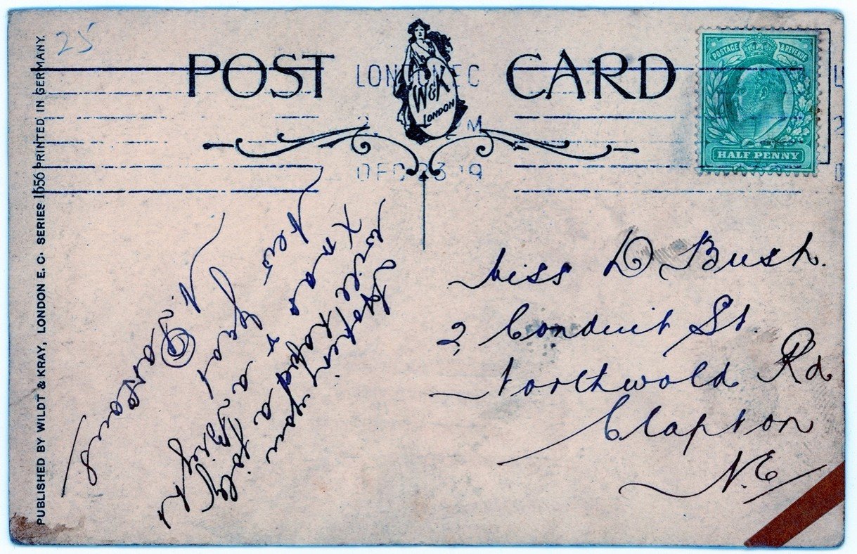
A postcard that caught my attention for such a reason was addressed to Miss D. Bush, from N. Parsons, postmarked as 23 December 1919. It was sent to ‘2 Conduit Street, Northwold Road, Clapton’. It was not the address, per se, but the fact that it didn’t exist. I have traipsed up and down Northwold Road countless times and was certain that a Conduit Street does not exist there. In trying to place the location of its initial delivery, postcard 0504 revealed a pattern of change and movement across London, emanating from individual actors, such as Daisy, state-led incentives, and commercial interests.
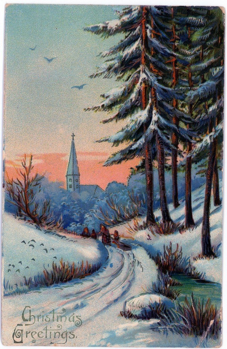
It was a Christmas card, its brevity in keeping with many of the cards we come across. The design is beautiful, an illustrated snowy scene with a church, with a swirled font, too, is typical of many from that period.
Finding Conduit Street.
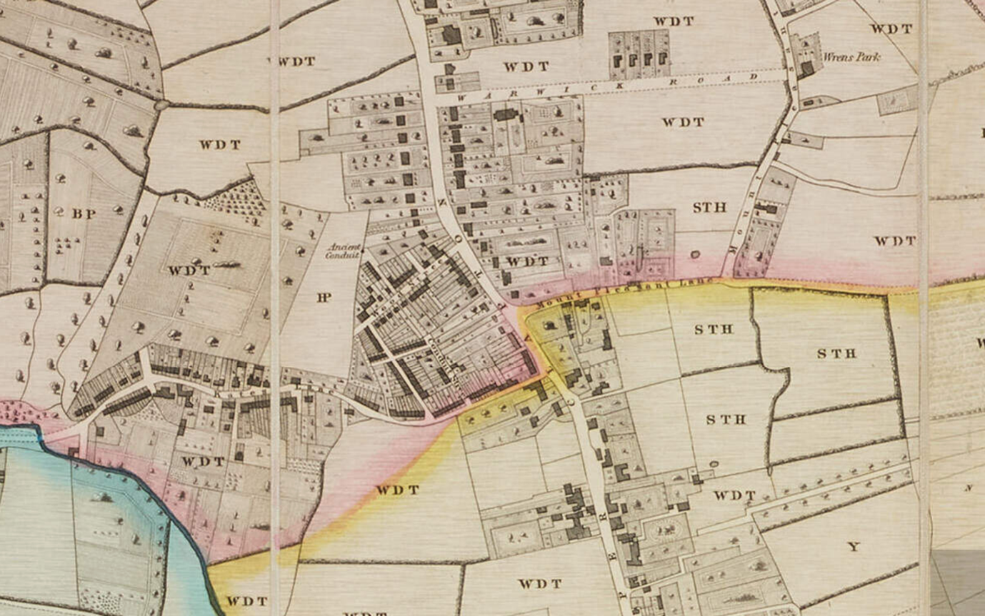
A map published in 1831 covering the parish of St John at Hackney reveals a Conduit Street jutting off from Kate’s Lane, now known as Northwold Road. The imprint of Conduit Street lines up with today’s Rossendale Street, and Wood Street, to the north, is now known as Rossington Street.
Conduit Street is also seen in sheet two of Charles Booth’s poverty map of 1889-99. This was the second edition, following the first based on surveys conducted ten years prior and covering a smaller area, The poverty maps, using Stanford’s Library Map of London and Suburbs as a base, use colour-coding to elucidate the variance of living conditions for households and communities across London. Data was compiled through empirical research, with Booth and others conducting the survey engaging in street-level inquiries. Emergent was a stark depiction of wealth and class disparity, and gave a harrowing impression of the true level of poverty found in the city.
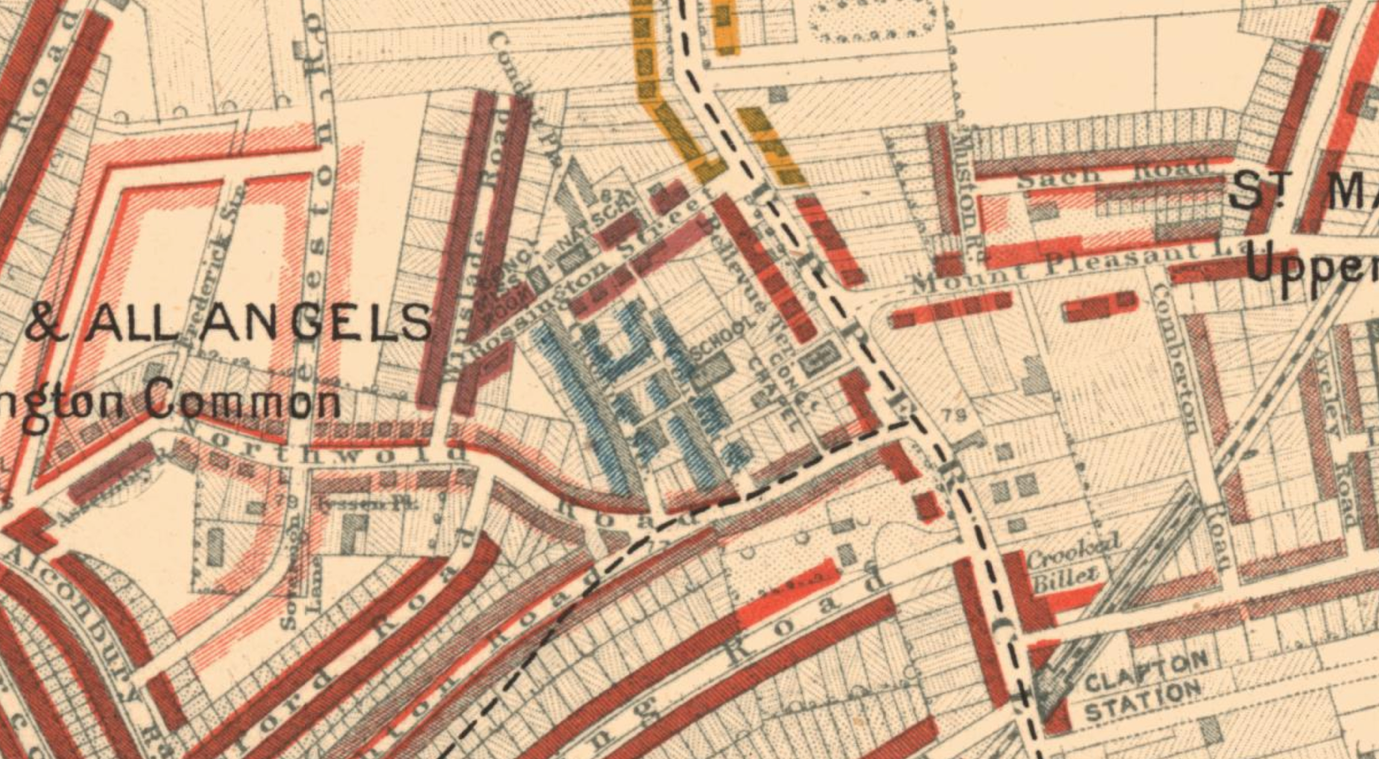
The area of Conduit Street appears as a light-blue enclave, surrounded by red. In his notes of this trip to the area around Conduit Street, Booth suggested that the street should be a mix of light-blue and purple. Light-blue indicated generally a poor standard of living and wages. Purple was a mixture of poor and more comfortable, and the surrounding areas of Conduit Street were middle-class to well-to-do.
Tracing D. Bush.
In the 1911 Census of England and Wales, living at 2 Conduit Street were Henry and Florence Bush, with their three daughters Mabel, Lilian, and Daisy Bush, the eldest. This is the Miss D. Bush to which the letter was addressed.
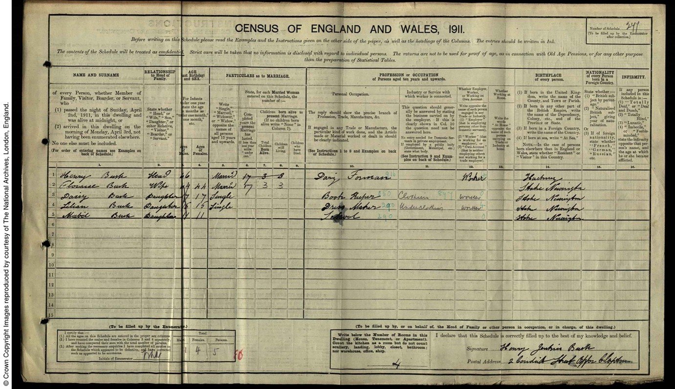
Daisy’s profession was a book keeper in the textile industry, with the census listing her as seventeen years old. Her appearance in the 1939 Register confirms she was born in 1893, in June. This would make her twenty-six years old at the time she received the postcard from N. Parsons in 1919. Daisy’s sister, Mable, aged fifteen, also worked within the textile industry as a dressmaker; this industry was a common source of employment for women and girls at the time, with this beginning to weave a tapestry of a working-class family in early twentieth-century London.
The 1921 census for the household, conducted two years after the postcard was dated, lists the postal address as 138 Northwold Road. 138 Northwold Road does not exist anymore, but based on the contemporary street numbers, it would be placed yards from the entrance to Conduit Street. Given that Lilian Bush does not appear on this census, the family may have downsized to somewhere close by. Listed as living at 2 Conduit Road in the 1921 Census is the five-person Lines household.
In 1921, Daisy Bush was working as a clerk for Ellis Buckle Ltd, with employer’s address listed as 9 Walbrook, in the City, about a stone’s throw away from Bank station. There was little to be found about the company itself, though clerical work, like the textile workers of the earlier decades, was a prominent avenue for which women to enter the public-sphere of the workforce, especially in the aftermath of the Great War and expanding businesses; though, women working as clerks were by no means a new development.
In the 1939 register, an emergency precaution on the outbreak of war, Daisy and her widowed mother are recorded as living in a household with Mabel, now married to a Thomas Leeper. Both Mabel and their mother are listed as working in positions of unpaid domestic labour, whilst Daisy, single, was still in employment as a register secretary. Also recorded as part of the household was a married man named Robert Williams who worked as a stock jobber and auxiliary fire fighter. They had moved further from Conduit Street by this point, now residing in Edmonton. It takes about an hour and two buses to make the journey between the two addresses today.
The move northwards to Edmonton gestures to a broader trend of suburbanisation in the interwar years. By the tail-end of the 1930s, the population of London’s suburbs had boomed by 2.5 million, the geographic radius of what we call London similarly expanding. Facilitating this was the expansion of the public transport network across London. This was particularly noted in North-West London, developments of the Metropolitan Railway heralding ‘Metro-Land,’ so dubbed in promotional materials produced by the Metropolitan Railway, which would in 1933 become incorporated into the precursor of the London Underground we know today. Whilst it had its specificities, Metro-Land was not the sole stop for suburbanisation, Edmonton itself being served by Silver Street station, operational since 1872 and now a stop on the Weaver Line of the London Overground. New rail links and, indeed, recognition of the importance of these earlier local networks, contributed to the changing landscape of London, both infrastructurally and demographically. Daisy Bush’s relocation to Edmonton is one person’s story in the broader movement.
Building as Rossendale Street.
By the time the Bush family had established themselves in Edmonton, Clapton’s conduit street no longer appears in the records. Many streets were renamed around London, largely due to duplication. A concerted effort to rename streets went into full thrust in the 1930s, converging with another facet of the radical restructuring of London’s residential geography.
The 1930 Housing Act heralded a wave of slum clearance across the country, building on pressure already mounting on local councils stemming from the 1919 Housing Act.
The Act compelled private landlords to sell slum housing to local councils, the slum housing was then cleared and new housing erected on the site. These new homes were often blocks of flats devised as five-storey walk-ups for efficient usage of ground space. By 1939, around 240,00 slum houses had been cleared, with some 700,00 new homes built. Accompanying this municipal undertaking was a deluge of promotional materials produced by both London County Council and various borough councils, such as this short-film produced by Hackney Council.
Also, the film ‘Housing Problems’, released in 1935, documents the media diffusion of contemporary overcrowding and slum-housing. It also projects a certain optimism courted by this council-funded social work. These L.C.C. homes weren’t the first council blocks built by the council, but they remain an enduring symbol of this interwar flurry of building. The new blocks featured prominently in L.C.C. publications, often highlighting their aesthetic and civic value. The blocks remain dotted around, a distinctive part of London’s residential landscape and a material testament to history of housing in the city, which remains in flux to this day.
Numbers 12 to 18 of Conduit Street were identified as clearance areas alongside various other streets in the vicinity in a series of documents from 1931, found in Hackney Archives (H/PD/3/6/1). Also within the Archives are records of the actual clearance order, this time for the entirety of Conduit Street, from 1934 (H/PD/3/3/12). It is reasonable to assume that following completion of the clearance order, Conduit Street was renamed and the site of council building, with a block remaining on the corner today, called Rossendale House. Incidentally, where 138 Northwold Road, the 1921 residence of the Bush family, may have been, is also the site of 1930s-era council housing.
Conclusions
The story of Daisy Bush and the address in which she resided when receiving postcard 0504 reveals the realities of an ever-changing London landscape. It provides a tangible reminder that the streets of London, whilst old, not unchanging, shifting cannily through intersections of industrialisation, social welfare, suburbanisation, and transport. Unravelling these intersections enliven built environments their interaction with social history. Whilst I have recounted the story of a specific street, and a specific postcard recipient, it was a narrative playing out across London, and indeed the country as a whole.
Madeleine Beaumont-Grice, Archive and Research Assistant